Day 1
Ty's pack weighed in pre-water at 35lbs, I came in at 29lbs. Ty was carrying most of the food, so by the end his pack was less than mine.
Waved farwell to Kalamazoo at 8:30am, arrived Grand Marais about 3:45pm. Plotted our backcountry routes and campsites at the visitor center (that's right, we really had no plan going into this! Thank you Brody for being incredibly helpful and patient!). Left Ty's car (loaded with ALL of his school stuff minus some valuable stuff (computer, projector) we threw in my trunk) there and then we beelined it in my car to Munising to begin our 42.4 mile hike BACK TO Grand Marais (PR is not really a place you can loop, its a straight line). We began hiking at 5:40pm with 5.1 miles to race to before dark to reach our first campground, The Cliffs.
We reached The Cliffs about 7:45pm and found we had the entire campsite (well there were only 3 of 'em I guess) to ourselves. We pitched our tents and made a hurried dinner of some old old old instant stew (from about '99, but it was still good) my Dad had given us. Not the best thing I've ever eaten, but we didn't die. Dark hit us as we were cleaning up and we didn't really inspect the bear pole well enough to get our bag hung properly in the night. If a bear HAD come along, I think he could've had a feast. Exhausted, we fell asleep.
5:10am, I wake up to distant thunder and some flashed of lightning. Grumbling a little I got out of my tent to pull my pack inside just in case it rained (I wasn't sure of the waterproofness of it, and didn't really want to find out). I fell back asleep until about 6:15am when the sky opened up with what had to be a monsoon! This tought me a valuable lesson: Just because the tent fly is attached does not mean it will stop water unless it is pulled TIGHT! I decided since I was only getting sprinkles in from splash damage that it wasn't worth it to wade outside and evaluate my error. The storm let up around 7:30am and I was able to fall back asleep (I enjoy storms, but the thunder was too irregular to get used to, I couldn't tune it out, apparently Ty couldn't either).
Day 2:
Crawled out of my tent at 9:30am to a sunny sky and still wet and dripping trees. Hung a clothesline and we threw our tents on them to dry up while we leisurely had breakfast. Today we only had to hike 6.4 miles to reach our next campground, Mosquito (despite the horrible sounding name, Mosquito was actually an awesome campsite along a little river mouth off of Superior, this and Chapel are the two most popular campsites in the park, and the only two with legit outhouses). From our tents we could hear the waves crashing (they were ocean size huge our first two days)
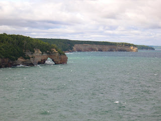
 Lake Superior with Grand Island in the background.

Miner's Castle used to have two "towers" but one collapsed in April of 2006.

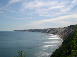
The beautiful (and miles long) coastline

Ty's pack weighed in pre-water at 35lbs, I came in at 29lbs. Ty was carrying most of the food, so by the end his pack was less than mine.
Waved farwell to Kalamazoo at 8:30am, arrived Grand Marais about 3:45pm. Plotted our backcountry routes and campsites at the visitor center (that's right, we really had no plan going into this! Thank you Brody for being incredibly helpful and patient!). Left Ty's car (loaded with ALL of his school stuff minus some valuable stuff (computer, projector) we threw in my trunk) there and then we beelined it in my car to Munising to begin our 42.4 mile hike BACK TO Grand Marais (PR is not really a place you can loop, its a straight line). We began hiking at 5:40pm with 5.1 miles to race to before dark to reach our first campground, The Cliffs.
We reached The Cliffs about 7:45pm and found we had the entire campsite (well there were only 3 of 'em I guess) to ourselves. We pitched our tents and made a hurried dinner of some old old old instant stew (from about '99, but it was still good) my Dad had given us. Not the best thing I've ever eaten, but we didn't die. Dark hit us as we were cleaning up and we didn't really inspect the bear pole well enough to get our bag hung properly in the night. If a bear HAD come along, I think he could've had a feast. Exhausted, we fell asleep.
5:10am, I wake up to distant thunder and some flashed of lightning. Grumbling a little I got out of my tent to pull my pack inside just in case it rained (I wasn't sure of the waterproofness of it, and didn't really want to find out). I fell back asleep until about 6:15am when the sky opened up with what had to be a monsoon! This tought me a valuable lesson: Just because the tent fly is attached does not mean it will stop water unless it is pulled TIGHT! I decided since I was only getting sprinkles in from splash damage that it wasn't worth it to wade outside and evaluate my error. The storm let up around 7:30am and I was able to fall back asleep (I enjoy storms, but the thunder was too irregular to get used to, I couldn't tune it out, apparently Ty couldn't either).
Day 2:
Crawled out of my tent at 9:30am to a sunny sky and still wet and dripping trees. Hung a clothesline and we threw our tents on them to dry up while we leisurely had breakfast. Today we only had to hike 6.4 miles to reach our next campground, Mosquito (despite the horrible sounding name, Mosquito was actually an awesome campsite along a little river mouth off of Superior, this and Chapel are the two most popular campsites in the park, and the only two with legit outhouses). From our tents we could hear the waves crashing (they were ocean size huge our first two days)
 Lake Superior with Grand Island in the background.
Miner's Castle used to have two "towers" but one collapsed in April of 2006.

The beautiful (and miles long) coastline

Tyler stopping to enjoy the view.


Mosquite Falls. This is unfortunately a regrettable story. Day 2 taught us the value of "pacing" and that it is basically a human law that after every hour of hiking, a 5 minute (minimum)sitting break is needed regardless of how fast we were walking. We were not good about stopping in a timely manner until we learned the hardway, by feeling absolely wiped when we got to Mosquito. I personally felt worse on this day than on our 13 mile day 4. The last 1.5 miles was grueling and I think my feet were crying. So naturally we set up camp and feel a little better and Tyler really wants to hike up to Mosquito Falls which is 1.6 miles away! Granted without packs, but I was still skeptical and really just wanted to go read or something on the shoreline. Eventually I felt that I could not let him gain an extra hike on me so I agreed to go and we set out at a fast trot. 1.6 miles (uphill) later we got this view. Totally dissappointing! We do see that the trail continues in a loop down the other side of Mosquito River so we trek on hoping this way will be shorter. False! What would turn out to be 0.3 miles later we find a sign that says it is NOW 1.6 miles back to our campground. [Insert profanity]. Ty decides to jog back to get in shape for club soccer while I stare incredulously at his fading form. [Insert much more profanity] I realize I can't let him run back while I walk, so I set off at a trot with protesting feet in hiking (aka walking, NOT running) shoes. Once I'm loose it briefly felt good to run, so I stupidly increased my pace (I should point out this isn't some high school track, this is a very up and down trail full of roots, boardwalks over swamps, rocks, and sand). About half way back I catch up to my walking brother (who claimed he rolled his ankle) and passed him. Sweating, tired, feet feeling like if they had a gun they would shoot me, I entered the home stretch and promptly kicked (nailed, blasted, hit at killling speed) a rock/root that stubbed my toe, broke the toenail, and made my foot go briefly numb before the pain set in. I walked/hobbled another 100 yards and found myself back at camp! So close! The toe would be fine, but I would battle a blister the size of a 50 cent piece on the back of my heel the rest of the trip. Stupid Mosquito Falls!
I'd like to clarify a few things that I could've worded better. There are 2 different ways to camp at the park. There is your basic rustic campgrounds (of which we hikeded through a couple), no electricity, but outhouses (very nice ones, for outhouses) and a water pump. These had all sorts of campers, RV's, and tents set up at and seemed very nice (plus they were on the beach!). What we did was camp at the backcountry sites. For instance our first night was at The Cliffs. We reserved this site at the visitor center, and their were 3 different camping sites at The Cliffs. These go on a first come, first serve basis for the people who have registered for it. So first one to each site has first dibbs on location. We were never the last people at a camping site, so we usually had a couple of different options.
Day 3
The day started sad when I realized that my camera had been left "on" all night and my battery was about dead (limiting my picture taking for the remaining part of our trip, but it never did die). Stupid switch location. Today Ty's camera also broke down when for no reason his zoom become dysfunctional (until mysteriously returning to function on our last day) and all of his pics up to this point were erased.
Camera setbacks behind us we set out and hiked 10 miles from Mosquito to Beaver Creek. This was our last day of cliffs, but also our best day. We hiked past Chapel Rock, Grand Portal, and Spray Falls (see pics below) and spent a lot of time 200' above the water. Beaver Creek was an awesome backcountry site, easily our favorite! It's located near the beginning of 12-mile beach (really, it's at least 12-miles, we hiked the whole thing on our journey) where the creek runs out to the water. The sites all filled up, but they were seperated enough where we felt alone with the lake. I even washed up in the nude in Superior and never saw anyone. Very peaceful and relaxing, plus at night there wasn't a cloud and we were treated with a collage of stationary stars (way way way more than you can see in Kalamazoo) and shooting stars.

Tyler resting and enjoying the view

Grand Portal

Another arch before Grand Portal

Spray Falls. We hiked up right to where the water pumps out over the edge, very cool.

A tree gone for a swim, making a break for Canada. Reminded me of the tree-things in Lord of the Rings.

Our campsite at Beaver Creek. Lake Superior is just over the sand hill!

The cliffs fading into 12-mile beach. The point way out on the left is what we had to go around to reach our last campsite.
Day 4
Long day, hiked Beaver Creek to Au Sable East. Total of 13.3 miles. Most of it is across 12-mile beach, so there wasn't much need to stop and sight see every 10 minutes, so we actually made really good time and it only took us 6.5 hours (including breaks and a swim).

A very old deck of a ship that crashed. The "graveyard" is a huge underwater mesa-like form that is 6' deep and over a mile from shore. Many ships have been claimed by it.
Day 5
Only 7.1 miles to go! Au Sable to the Visitor Center in Grand Marais. Of course we had to hike up the side of the 300' sand dunes which proved strenous, but for the most part we flew threw the hike.

Grand Sable Dunes, rising 300' out of the water. This climb was intense!

Sable Lake, only a mile or so left in our journey! The end was kind of a bummer as part of our hike was by way of road, and then when we finally made it to Ty's car it had a flat tire. Not our happiest moment.
No comments:
Post a Comment